Theoretical Aims: The Literature of Place & Space
The pilot aims to create a template for 'literary GIS'. In other words, it suggests how digital mapping can be used to develop further thinking about the relationships between writers, landscapes, texts and readers. These theoretical concerns can be sub-divided into three different, yet overlapping, areas: the field of spatial literary criticism; issues regarding electronic texts and textuality; and reader-response theory.
Spatial Criticism
- Does digital space offer a new medium for exploring what J. R. Watson describes as the 'swirling movement' (p. 38) between writer, place, text and reader?
- Does the movement beyond the codex serve to open up new thinking regarding literary spatialities? Can the use of multiple perspectives - facilitated by the 2.5-d space of Google Earth - facilitate fresh thinking about the textual articulation of embodied spatial experience? Can it offer different modes of representation - and, by extension, ways of thinking - which are not possible within the bounded space of the book?
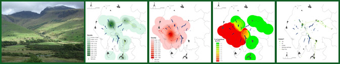
- How can GIS technology be used to represent, and to examine, the textual layering of places and spaces over time? More particularly, how can a literary GIS facilitate the articulation of a concept of 'spatial intertextuality'?
- Is there a way in which GIS mapping can be used to test the theory of 'social space' articulated by Henri Lefebvre in 'The Production of Space' (pp. 33-40)? Can digital mapping be used to explore the intersections between 'spatial practice' (the everyday movement through the landscape); 'representations of space' (the bureaucratic organisation of the topography); and 'representational', or lived-in, spaces (the complex intermingling of actual and imaginative geographies).
- Building upon Franco Moretti's influential theory of a 'literary geography' ('Atlas', p. 3), in what ways can (digital) maps be used to develop further critical thinking about the literature of place and space? Can the use of digital space enable the spatial critic to transcend the conceptual limitations of Moretti's work? Can GIS technology facilitate the development of spatial thinking which moves beyond principles of Euclidean geometry (the one-dimensional representation of place)? 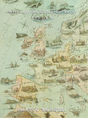
- How can GIS technology be used to further the understanding of imaginative and/or emotional geographies? Is there a way of drawing upon practices in 'fuzzy geography' to create metaphorical maps of literary texts?
Electronic Texts and Textuality
- What editorial decisions, if any, have been made during the process of textual digitisation? What effect do these decisions have on the text? Are these editorial decisions made transparent on the project website?
- Does the computer screen provide a suitably fluid space for exploring complex and unstable textual histories? Does the movement away from the printed page, and into digital space, facilitate the understanding of the 'unfixity' of particular texts?
- Can the creation of a literary GIS involve engagement with existing theoretical work in the field of electronic textuality? Can the editor draw upon the textual criticism of Jerome McGann, Kathryn Sutherland, George Landow and, more recently, Mark Nunes, to theorise the digitisation process? Is it possible for the spatial critic to bring together contemporary theories regarding both electronic textuality and literary spatiality?
Reader-Response
- This element remains undeveloped in the pilot project but can a literary GIS be made accessible to a range of users? Can the digital map be used by literary critics, geographers, teachers, students and general readers? Can GIS generate interest in both the native dweller and the tourist?
- Building on these core questions, is there a way in which the website can provide a space for documenting a range of reader responses to geo-specific literature? Can users be invited to create their own cartographical readings of literary texts?
- In the long-term, these enquiries point towards the possibility of an interactive website: a digital space in which users are able to map out the geographies of particular texts and their layered, textual associations with specific geographical sites. Ultimately, then, is it possible to create a fluid, spatial intertext of a particular landscape? Can GIS technology form the basis for exploring the reading (and mis-reading) of the literature of place and space? Can a literary GIS examine readerly, as well as writerly, spatialities?